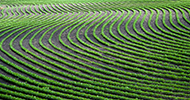
AGRICULTURE
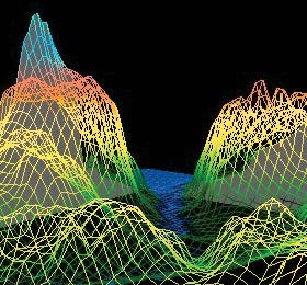
A GIS captures, stores, analyses, manages and presents data that is linked to location. The data may consist of, for example, environmental or resource data. GIS is also used to map attributes for insurance companies, municipal planning, utility companies and others. The positions associated with the data can be provided from a GNSS receiver. GIS applications can generate detailed contour maps from the data and present these maps in a digital form, as illustrated in Figure 66.
Weather forecasting impacts our society and economy in very tangible ways, influencing important decisions business leaders and public safety officials make every day. One of the important components in accurate forecasting is knowing the water vapour content in the atmosphere. Water vapour plays a critical role in the global hydrologic system, and is a key component in cloud formation and the lower atmosphere’s chemistry. Despite its important role in forecasting, water vapour is difficult to observe, especially during severe weather.
GNSS receivers are being used to help observe water vapour, one of the major components in the tropospheric delay of GNSS signals. These signal delays can be estimated and used to retrieve the total column water vapour, also known as Integrated Precipitable Water Vapour (IPW).
A network of GNSS receivers spread across the forecasting area makes it possible to observe IPW accurately and reliably in all weather conditions. These observations can be fed into weather forecast models to better predict impactful weather events such as hurricanes and large storms.
An article (Using GPS for Better Weather Prediction) about using GPS receivers to measure water vapour is in the 2018 Velocity magazine available at: resources.hexagonpositioning.com/using-gps-weather-prediction.