AGRICULTURE

Your biggest client has its biggest project on the runway, literally: construction of a gleaming new international airport terminal miles from urban infrastructure. Yesterday a late-arriving environmental impact statement dictated that a core set of buildings must be relocated—fast. The work crews have already arrived onsite, the heavy equipment is chugging away, costs rise by the minute; yet no work can be done without a new set of plans.
Even a UAV fly-over survey of the new building footprint would take hours to collect data at the required precision for construction, and hours more to download corrections and perform post-processing. With other corrections services, this would create a full day’s delay or more. Time is money; crew and equipment downtime is money lost.
Here's help when it’s most needed. Waypoint 8.90 software’s Precise Point Positioning Ambiguity Resolution(PPP-AR) from Hexagon | NovAtel, combined with TerraStar Near-Real-Time (TerraStar-NRT) corrections, gets the job done faster than ever possible before. And it furnishes up to a45% increase in horizontal position accuracy. Because it can obtain such increased accuracy from shorter datasets, you can perform the survey very quickly, spend less time in the field, and hand your client a superior deliverable.
Sooner.
As this article shows, PPP-AR with NRT achieves sub-centimeter accuracy in static positioning of six hours or more, and decimeter-level accuracy in kinematic positioning.
Ambiguity Resolution
Precise Point Positioning is a positioning technique that removes or models GNSS system errors to provide centimeter-level accuracy. It applies centimeter-level satellite orbit and clock corrections, estimated from a global network of satellite tracking stations, and filtered with precise but ambiguous phase measurements. These corrections, combined with the PPP algorithm in Waypoint8.90 software, results in a centimeter-level processed position.
The service is provided worldwide and without additional infrastructure like other corrections services. For post-processing applications, this means faster data collection with more accurate results.
PPP calculates positioning through carrier-phase measurements which have the potential to be ambiguous. This ambiguity can be resolved through specialized algorithms like PPP-AR in Waypoint Software but still requires time for convergence. TerraStar-NRT reduces this convergence time even further, processing highly accurate data faster.
The value in the TerraStar-NRT subscription is the speed at which you can get the PPP corrections needed for your post processing: within minutes of the real-time data collection rather than having to wait until the next daylike you would with other sources.
For example, a 15-minute PPP-AR airborne survey is possible (as opposed to the 2- to 3- hour flights other methods would require) as users don’t have to rely on additional infrastructure. With corrections obtained within an hour, PPP-AR can deliver 3-centimeter accuracy. In addition to a much shorter initial convergence period, PPP-AR enables quick re-initialization of short data gaps. TerraStar-NRT further removes errors and resolves integer ambiguities from these calculations by providing precise GNSS satellite orbit and clock data, and code and phase biases.
Tests demonstrate this powerful time and money-saving capability. These benefits translate into real advantages for commercial applications such as surveying and mapping—particularly airborne mapping—as well as construction, precision agriculture and offshore positioning.
PPP-AR’s ambiguity resolution engine, available in version 8.90 of Waypoint Software, does all this by significantly improving PPP convergence. Based on the TerraStar-CPRO service from NovAtel, PPP-AR currently requires use of an OEM7®or OEM6® GNSS receiver to collect the data, and an NRT software subscription. The NRT service gives access to precise GNSS satellite orbit and clock data as well as code and phase biases. These biases affect the ability to resolve the integer ambiguities in PPP.
Using the Terrastar-NRT data to remove them from calculations makes the PPP-AR accuracy the highest attainable without the time and expense of establishing a reference station for Real-Time Kinematic (RTK) measurements. Similar to TerraStar-C in performance, TerraStar-NRT delivers corrections and biases every 15 minutes.
NovAtel engineers recently verified the accuracy and quickness of the PPP-AR software in an extensive suite of static and dynamic tests. They compared the performances of the new PPP-AR filter with that of the previous best, Waypoint’s float PPP filter. The results are compelling, both in terms of increased accuracy and faster results.
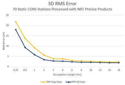
For the static evaluation, 70 static surveys were processed using occupation lengths ranging from 15 minutes to 24 hours. The PPP-AR filter saw a reduced 3D RMS error at all occupation lengths, and particularly faster horizontal convergence.
In the kinematic test, a two-hour vehicle survey collected data in light urban, mixed GNSS signal conditions, traveling more than 76 km in the process. In this case, the tightly coupled PPP-AR results improved by a factor off our relative to results with the tightly coupled PPP float filter.
Post-processing the data is where the PPP-AR solution reveals its power. In the case of kinematic tests, it maximizes the accuracy of the solution by processing recorded GNSS and inertial data forward and reverse in time and combining the results. The moving receiver’s position, velocity and attitude solution can be smoothed and output. The process also provides the ability to assess positioning reliability and accuracy.
Why It Works
Fast availability (15min latency)TerraStar-NRT corrections have multiple advantages over other correction services that offer precise satellite clock and orbit data. Users with a WaypointNRT license may benefit from:
Users with a NovAtel GNSS receiver also benefit from the satellite code and phase biases that are required for the
faster PPP convergence.
Static Testing Set-up
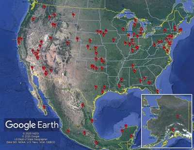
The static test used seventy permanently operating reference stations from the Continuously Operating Reference Station (CORS) network. The stations were chosen based on their receiver type (NovAtel receivers),data quality, and completeness over a 24-hour period (November 7, 2019).The National Geodetic Survey (NGS)provides published positions and station velocities, which were used to compute the processing errors. Figure1 shows a map of the stations, well distributed throughout the continental USA, Alaska and Mexico.
Each 24-hour dataset was processed using occupation times from 15 minutes to 24 hours. Multiple equally-spaced processing runs were done on the shorter occupation lengths to help ensure many samples with a high variability in satellite geometry were represented in the results. In total, more than 2,500 processing runs generate results for each PPP filter. All data was processed using TerraStar-NRT precise products. Processing and analysis were automated with the Waypoint Software Developers Kit (SDK).
Static Test Results
Figure 2 illustrates the 3D RMS errors of each filter as a function of occupation length. Table 1 (see the PDF version for Table 1) tabulates the horizontal and vertical components of the RMS error for each filter.
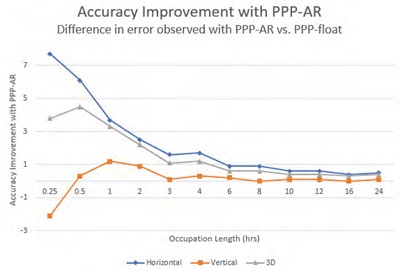
Figure 3 shows the improvement inaccuracy provided by PPP-AR vs PPP-Float at various occupation times. Theresults reveal that most of the benefit of the PPP-AR filter is delivered in occupation times of less than 6 hours, during which PPP-AR reduced the 3D error by up to 4.5 cm, and the horizontal error by up to 7.7 cm.
Kinematic Test Set-Up
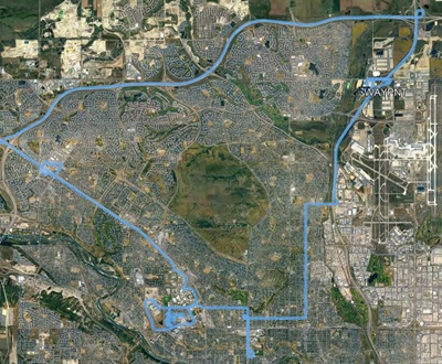
To mimic the results that could be obtained with a survey-mapping UAV, NovAtel engineers collected a two-hour data set covering more than 76km along a light urban driving route. Residential neighborhoods and roadways with occasional overpasses made up most of the survey. The driving avoided completely open areas for extended periods and also avoided the downtown core. The map in Figure 4 shows the test route.
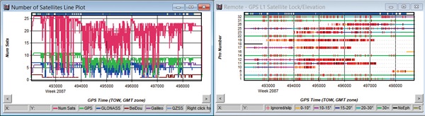
GNSS+INS data was collected with a SPAN® PwrPak7-E1 from NovAtel, which contains an EG320N MEMS IMU from Epson. Figure 5 gives the total number of satellites used in the solution and the satellite lock/cycle slip plot of the GPS L1 signals.
The maximum distance to a base station operating on the roof of the Hexagon Calgary Campus was just over 14 km. The base station generated differential tightly coupled reference solution. An average of 21satellites were used in the post-processed trajectory. The reference trajectory achieved fixed integer status on 96.2% of the survey, and over 95%of the dual fixed integer solutions had a 3D forward/reverse processing difference under 5 cm.
Kinematic Test Results
A tightly coupled PPP solution was processed using the Waypoint PPP-float filter and the PPP-AR filter. Both filters used near real-time precise satellite clock and orbit
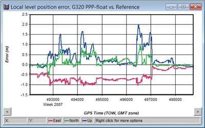
Conclusions corrections from TerraStar, which Waypoint users can access with an NRT license. The satellite code and phase bias data contained in the NRT precise products issued by the PPP-AR filter to improve convergence/re-convergence in mixed GNSS signal conditions. Figure 6 and Figure 7 show the position difference between the PPP TC solutions and the reference trajectory at the same scale, and Table 2 summarizes the results.
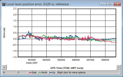
The static and kinematic test results demonstrate that the PPP-AR filter produces significant improvement in PPP convergence. The results achieve sub-centimeter accuracy in static positioning of six hours or more, and decimeter-level accuracy in kinematic positioning. Users with NovAtel GNSS receivers will now benefit from both the low latency of the TerraStar-NRT precise orbit and clock data, delivered every15 minutes, and improved convergence on shorter surveys.
Users will also see improved performance when surveying in mixed GNSS signal conditions. This new PPP-AR filter maximizes the post-processing value delivered to NovAtel customers.
Acknowledgments
NovAtel would like to thank the National Oceanic and Atmospheric Administration (NOAA) and the National Geodetic Survey (NGS) for the publicly available base station data used.
Read the full PDF here: