AGRICULTURE

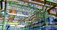
It would be hard to overestimate the importance of Geographical Information Systems (GIS) in today’s world. These technologies, designed to capture, store, manipulate, analyze, manage and present all types of spatial or geographical data are generally powered by advanced GNSS technologies.
GIS serves many disciplines, from real estate to public health, landscape architecture and archaeology, national security and sustainable development, and many more.
With more, better and easier-to-use technologies coming online, GIS users, it would seem, are getting a bit spoiled.
Stefan Geissler is managing director of PPM (Precise Positioning Management) GmbH. He says, “People who use GIS like to work with big screens and huge data sets, and our PPM10xx is the ideal answer for the new trend in GIS, which is to use tablet PCs or big-screen smartphones in the field.” These “field computers” enable users to edit live data employing wireless connections, enhanced by high-level GPS units such as those produced by PPM with embedded NovAtel components. Users can create maps and analyze data directly on site, eliminating the need to import, update, and post-process data back at the office after the fieldwork is completed, making the whole process simpler and more efficient.
Founded in 1998, PPM is located in Penzberg, Germany, about 40 kilometres south of Munich. The company develops and manufactures its own GNSS-based products and distributes GNSS products from NovAtel.
PPM is competing in a dynamic GIS market, where costs are coming down and continual upgrades in hardware and software components are being made, but Geissler says there is still room for improvement.
“The problem for GIS users is that the internal GPS sensors found in today’s tablets and smartphones are not accurate or reliable enough for their needs,” Geissler explains.
“Our PPM10xx, with NovAtel’s OEM617™ inside, is lightweight and easy to use and it delivers the perfect, precise GNSS enhancement for our customers.”
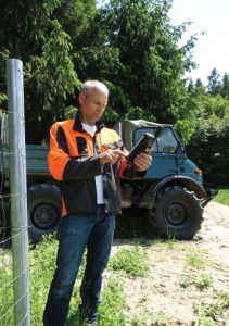
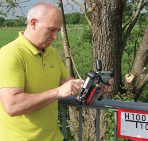
One such customer is Germany’s ili gis-services. Founded in 1994, the company calls itself“a competent partner in the field of GIS andGPS for users in the field of spatial planning.” Itsmain focus lies in the distribution of GIS hardwareand software for both desktop and mobilesolutions, adaptation of software products forcustomer-specific needs, and the processing of major GIS projects, often in collaboration withconsultants from various disciplines.
“ili gis-services has been a PPM partner for more than 10 years,” says Geissler. Among other things, they are experts in GPS for GIS applications, being an ESRI software partner.” That means they distribute ESRI’s GIS and geodatabase management programs that currently hold more than 40 percent of the worldwide GIS software market, including the widely used ArcGIS Desktop application.
“Their clients are professional GIS users working in forestry, landscaping, land appraisal, ordinance clearance, and public utilities, just to name a few,” says Geissler.
A typical GIS field system supplied by ili gis-services might include a field computer, i.e., a tablet or smartphone with appropriate software, an enhanced GNSS device, such as PPM’s 10xx, and a GPS antenna.
The 10xx is essentially a small box with one USB port for connecting to the computer and another port for connecting to the antenna. In addition to data transfer, the USB port also supplies the necessary five volts of power from the computer to the 10xx.
It tracks all current GNSS constellations including GPS, GLONASS, Galileo, BeiDou and Japan’s Quasi-Zenith Satellite System (QZSS), and features configurable channels to optimize satellite availability. The OEM617 is also “future ready,” with upgradable software to track new GNSS signals as they become available.
“The 10xx GNSS Sensor is the simplest and most affordable way to add a professional, precise GNSS receiver to any kind of IT device, like smartphones, tablets and notebooks,” says Geissler, “with USB connectivity, regardless of which OS is installed on the device. We offer USB drivers for Windows XP, 7, 8, 10, CE and Mobile, Linux, IOS, MCOS and Android.
“I’m not aware of any other product that supports this wide a range of hardware and operating systems,” he says.
“On top of that, the 10xx is very light, at just 130 grams, and it is extremely easy to handle. Bundled with our own ‘GNSS Commander’ software, which supports NTRIP communication, the 10xx is even more powerful.”
Network Transport of RTCM via Internet Protocol (NTRIP) is an application-level protocol used to stream GNSS differential correction data over the Internet.
NovAtel includes NTRIP server and client functionality on a variety of its OEM6® receivers, including the OEM617. This allows quick and easy integration into any v1.0 or v2.0 NTRIP caster and ensures universal support for world-wide GNSS infrastructure for base and rover applications.
“With GNSS Commander, available for Windows 7, 8, 10 and Android, you also get the ability to perform global or local coordinate transformations, position visualization on Google Maps and reconfiguration of the 10xx Sensor itself,” Geissler says.
Geissler, who received a physics degree from Munich University of Applied Sciences in 1994, says he first came into contact with NovAtel in 1996, when he was working for GPS Gear GmbH. Geissler was working as sales manager and GPS product specialist.
GPS Gear was an Ashtech and NovAtel dealer. From 1997 to 2000, he worked for Ashtech and in 2000 he moved to PPM. “We became a NovAtel distributor in 2006, covering Austria and Switzerland, and since 2015 we have also covered Germany,” he says.
Geissler’s main contact on the NovAtel side is Rick Blighton, senior sales manager for Europe, Middle East, Africa, Russia, and CIS for the past 10 years.
“Stefan and I have worked together in the GNSS industry for over 20 years,” Blighton says. “PPM is a specialist dealer for NovAtel, and I have the pleasure of working very closely with Stefan and their sales engineer Karl-Heinz Bergel.”
PPM sells their own system to the customer, ili gis-services, while NovAtel supplies the OEM receiver that is integrated into the PPM 10xx.
PPM has its own development department. “We do the electronic and mechanical design of our products in house,” says Geissler. For the most part, PPM works with contract manufacturers with the final assembly and quality tests done in house.
“The NovAtel OEM617 board offers a very good GNSS performance in an appealing form factor at a very competitive price,” he says. “NovAtel distinguishes itself from other GNSS manufacturers especially with its outstanding product quality, availability and its excellent support. The OEM617 is the engine, the core component, of our 10xx receiver, and the better the performance of the engine, the better the performance of the overall system!”
Blighton adds, “The NovAtel OEM617 is a powerful, small, multi-constellation GNSS receiver with excellent performance in terms of high-quality data, robust signal tracking, and highly reliable and accurate positioning.”
“Our 10xx can be used for any kind of GIS application,” says Geissler, “from a sewer line data base to a digital forestry inventory.”
In 2015, the 10xx was nominated for the Wichmann Innovations Award, voted annually by an independent jury of leading geopositioning professionals at the Intergeo trade fair in Germany.
Geisser says, “We believe that since its introduction in the summer of 2015, the PPM10xx GNSS sensor, with NovAtel inside, has become recognized as a very useful and innovative new product.”